|
Max flight distance (km):
|
20
|
|
Max speed (m/s):
|
18
|
|
Maximum climb speed (m/s):
|
10
|
|
Maximum descent speed (m/s):
|
6
|
|
Maximum flight time (min):
|
36
|
|
Max altitude (m):
|
6.000
|
|
Sensors:
|
Yes
|
|
Room:
|
Yes
|
|
Room specifications:
|
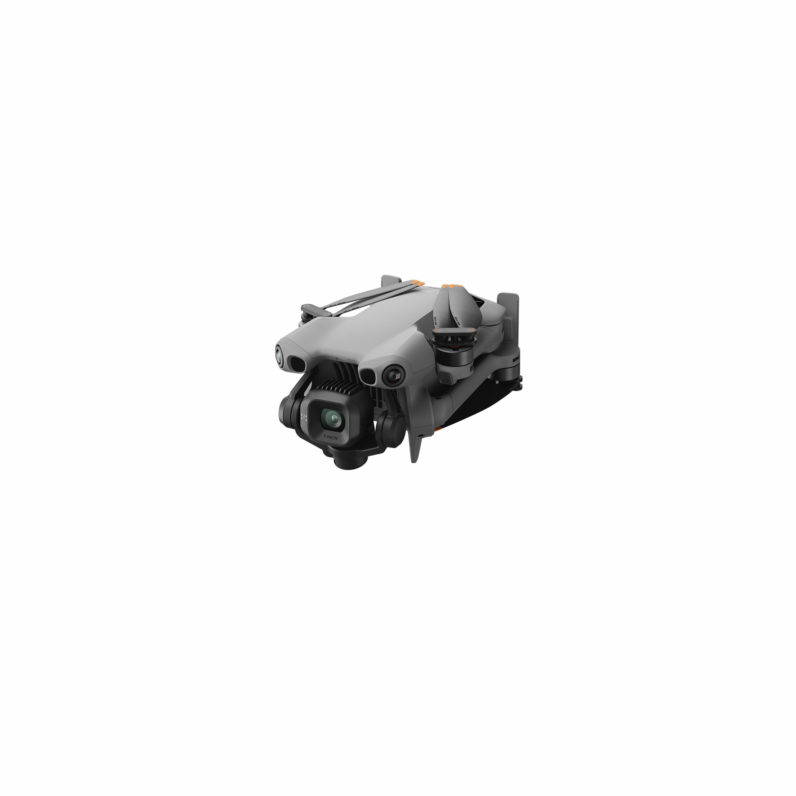
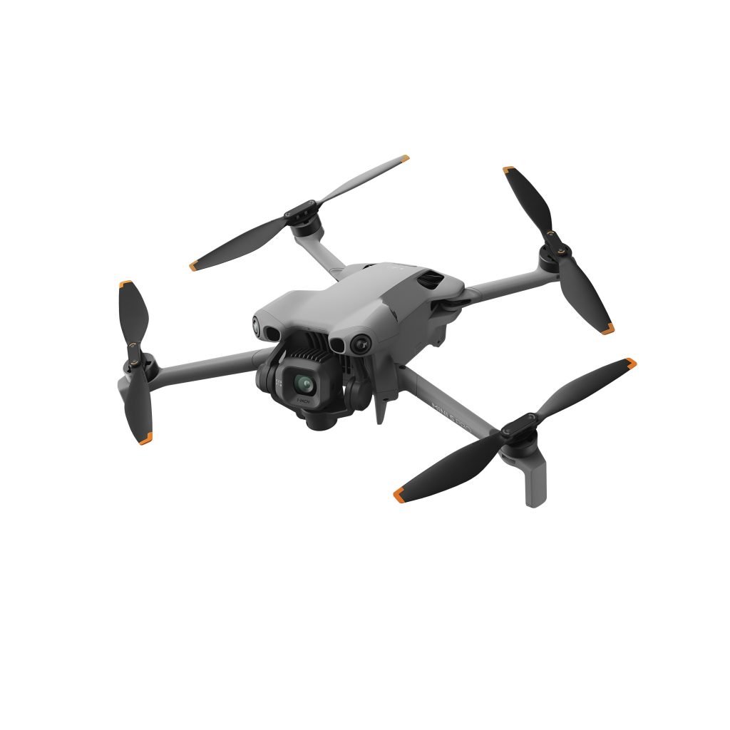
1″ CMOS, 50 MP effective pixels “FOV: 84°
Equivalent size: 24 mm
Aperture: f/1.8
Focus: 0.5m at 8″ “Video
Normal:
100-12,800 (Normal)
100-3200 (D-Log M)
100-3200 (HLG)
Slow Motion:
100-6400 (Normal)
100-3200 (D-Log M)
100-3200 (HLG)
Photo
100-6400 (12 MP)
100-3200 (50 MP)” “Photo 12 MP: 1/8000-2 s (2.5-8 s for simulated long exposure)
50 MP Photo: 1/8000-2 s” 8192×6144 “Single shot: 12 MP and 50 MP
Burst shooting: 12 MP, 3/5/7 frames; 50 MP, 3/5 frames
Auto Exposure Bracketing (AEB): 12 MP, 3/5/7 frames; 50 MP, 3/5 frames at 0.7 EV steps
Timed: 12 MP, 2/3/5/7/10/15/20/30/60 s; 50 MP, 5/7/10/15/20/30/60 s” JPEG/DNG (RAW) “H.264/H.265
4K: 4K: 3840×2160 at 24/25/30/48/50/60/120*fps
FHD: 1920×1080 at 24/25/30/48/50/60/120*/240*fps
* Frame rate during recording. The corresponding video is played in slow motion. Slow motion and 4K videos only support H.265 encoding.” MP4 (MPEG-4 AVC/H.264, HEVC/H.265) “H.264/H.265: 130 Mb/s
* When recording 4K/120fps video in D-Log M mode with DJI Mini 5 Pro, the video encoding bitrate can reach 130 Mb/s, which corresponds to a video frame rate of 120fps. However, since slow-motion video files are downscaled to 30fps, the length of the video displayed on the player is four times longer than the recording duration, and the bitrate of the analyzed downscaled file is approximately a quarter of the original encoding bitrate.” exFAT “Normal (FHD):
8-bit 8:4:2 (H.264)
Normal (FHD/4K):
4:2:0 10-bit (H.265)
HLG/D-Log M:
4:2:0 10-bit (H.265)” “12MP photo: 1-3x
4K: 1-3x
FHD: 1-4x”
|
|
Supported memory cards:
|
Recommended microSD cards: “Lexar Silver plus 64GB A2 V30 microSDXC
Lexar Silver plus 128GB A2 V30 microSDXC
Lexar Silver plus 256GB A2 V30 microSDXC
Lexar Silver plus 512GB A2 V30 microSDXC
Lexar Silver plus 1TB A2 V30 microSDXC
Kingston CANVAS GO! Plus 64GB A2 V30 microSDXC
Kingston CANVAS GO! Plus 128GB A2 V30 microSDXC
Kingston CANVAS GO! Plus 256GB A2 V30 microSDXC
Kingston CANVAS GO! Plus 512GB A2 V30 microSDXC”
|
|
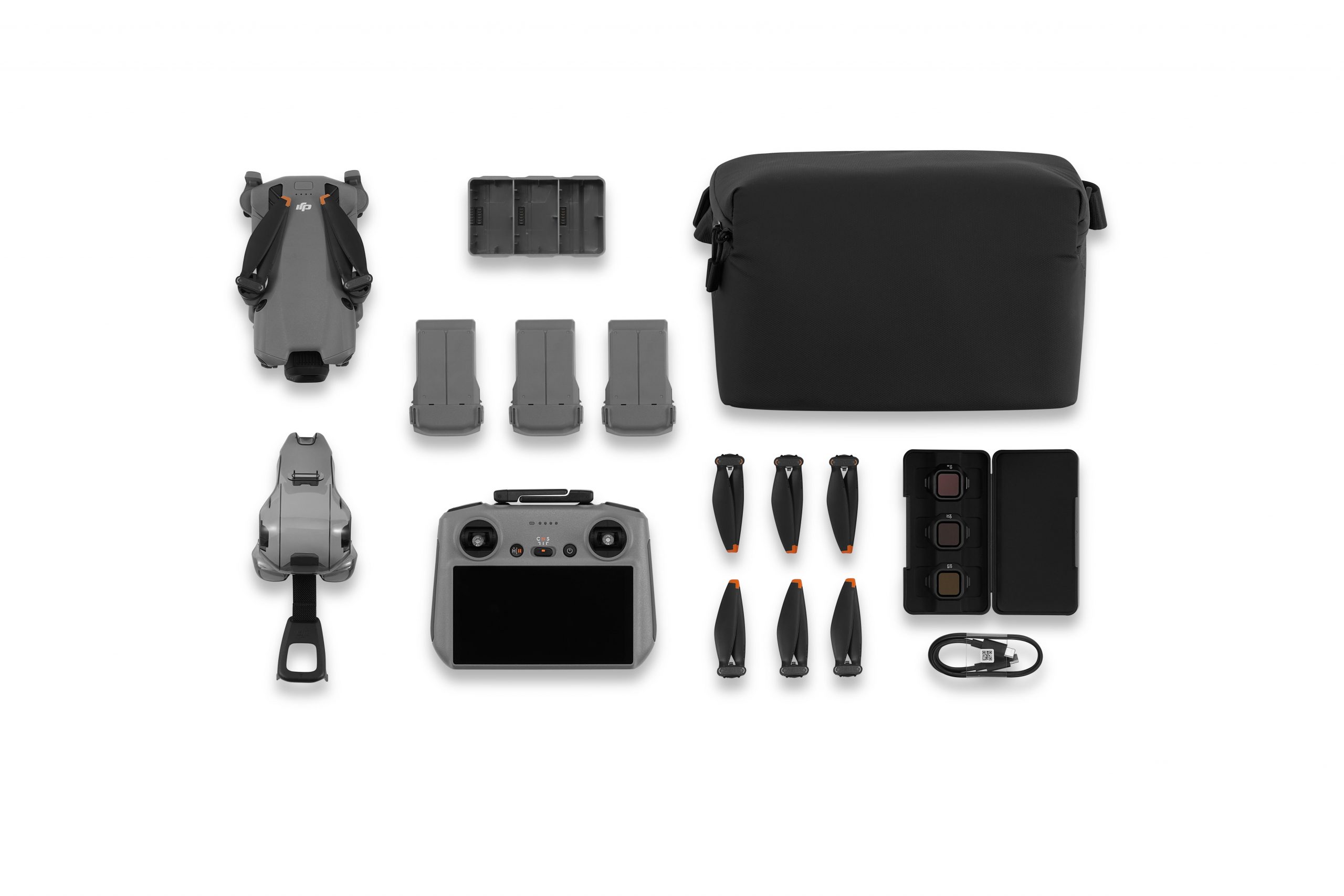
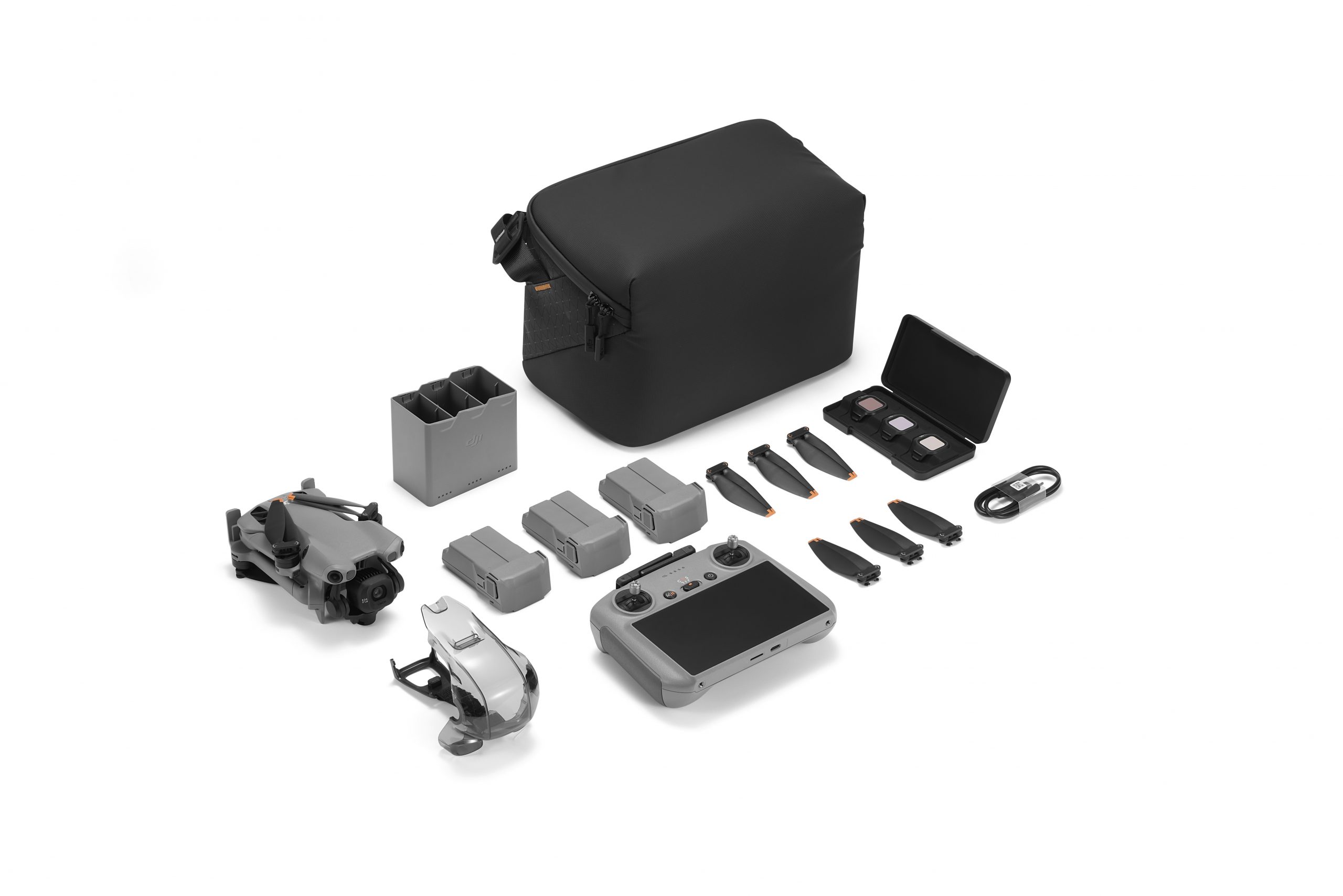
Drone battery type:
|
Li-ion
|
|
Drone battery capacity (mah):
|
2.788
|
|
Drone battery voltage (V):
|
7,16
|
|
Drone battery power (Wh):
|
19,52
|
|
Radio Control Frequencies:
|
“2.400-2.4835 GHz
5.170-5.250 GHz
5.725-5.850 GHz
Permissible operating frequencies vary by country and region. For further information, please refer to local laws and regulations.“
|
|
Maximum range of radio control:
|
Maximum transmission distance (unobstructed, with interference) “Strong interference: urban landscape, about 1.5-4km
Medium interference: suburban landscape, about 4-10 km
Low interference: suburban areas/sea, about 10-20 km
Data was acquired in accordance with FCC standards in an open, unobstructed space with common interference. It is used for reference purposes only and does not guarantee actual transmission distance.”Maximum transmission distance (with obstacles, interference) “Low interference and obstruction from buildings: approximately 0-0.7 km
Low interference and tree obstruction: about 0.7-4.5 km
Data was acquired in accordance with FCC standards, with obstructions and low interference. It is for reference purposes only and does not guarantee actual transmission distance.“
|
|
Radio control battery type:
|
18650 Li-ion, 22.32Wh (3.6V, 3100 mAh×2)
|
|
Radio control battery capacity (mah):
|
3.100
|
|
Radio control display:
|
Yes
|
|
Sensor Specifications:
|
Omnidirectional binocular vision system, integrated with a front LiDAR sensor and an infrared sensor at the bottom of the aircraft “Measuring distance: 0.5-18m
Detection range: 0.5-200m
Effective detection speed: Flight speed = 15 m/s
FOV: Horizontal 90°, Vertical 72°” “Measuring distance: 0.5-18m
Effective detection speed: Flight speed = 14 m/s
FOV: Horizontal 90°, Vertical 72°” “Measuring distance: 0.5-12m
Effective detection speed: Flight speed = 14 m/s
FOV: Horizontal 90°, Vertical 72°” “Measuring distance: 0.5-18m
Effective detection speed: Flight speed = 6 m/s
FOV: Front and rear 72°, side 90°” “Measuring distance: 0.3-14m
Effective detection speed: Flight speed = 6 m/s
FOV: Front and rear 106°, side 90°” “Front, rear, side and up:
Surfaces with recognizable patterns, with adequate lighting (lux > 1)
Inferior:
Surfaces with distinguishable patterns, diffuse reflectivity >20% (e.g., walls, trees, people) and adequate illumination (lux > 1)” “Front-facing LiDAR
Measuring distance (night): 0.5-25m (reflectivity > 10%)
FOV: up and down 60°, left and right 60°
Infrared downward sensor
Measuring distance: 0.3-8m (reflectivity > 10%)
FOV: front and rear 60°, left and right 60°”
|
|